

Loading
Hike
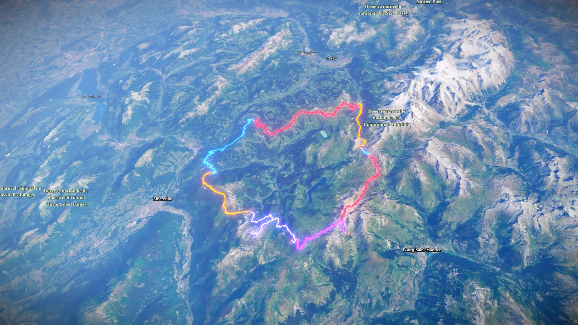
Les Contamines-Montjoie Randonnée
Aug 3, 2026 – Aug 9, 2026

Mapped by
Sandrine Betuing
The timeline
By the numbers
- Distance
- 128 km
- Ascent
- 7,576 m
- Descent
- 7,507 m
- Moving time
- 1d 16h 28m
Elevation profile
534 m → 2,695 m
Drag across the profile to follow the route on the map.
More stats
- Avg speed (moving)
- 3.2 km/h
- Avg speed
- 2.3 km/h
- Time
- 2d 06h 30m
- Avg heart rate
- 106 bpm
- Max heart rate
- 162 bpm
- Avg cadence
- 57 rpm
Per leg
Les Contamines-Montjoie Randonnée
- Distance
- 11.6 km
- Ascent
- 1,180 m
- Descent
- 15 m
- Moving
- 3h 39m
- Avg speed
- 3.2 km/h
- Avg HR
- 119 bpm
- Max HR
- 158 bpm
- Avg cadence
- 57 rpm
Les Contamines-Montjoie Randonnée
- Distance
- 2.73 km
- Ascent
- 197 m
- Descent
- 81 m
- Moving
- 1h 02m
- Avg speed
- 2.6 km/h
- Avg HR
- 123 bpm
- Max HR
- 146 bpm
- Avg cadence
- 53 rpm
Bourg-Saint-Maurice Randonnée
- Distance
- 16.1 km
- Ascent
- 927 m
- Descent
- 1,348 m
- Moving
- 5h 42m
- Avg speed
- 2.8 km/h
- Avg HR
- 107 bpm
- Max HR
- 154 bpm
- Avg cadence
- 59 rpm
La Plagne Tarentaise Randonnée
- Distance
- 11.3 km
- Ascent
- 742 m
- Descent
- 918 m
- Moving
- 4h 18m
- Avg speed
- 2.6 km/h
- Avg HR
- 104 bpm
- Max HR
- 162 bpm
- Avg cadence
- 57 rpm
Beaufort Randonnée
- Distance
- 20.4 km
- Ascent
- 1,414 m
- Descent
- 1,353 m
- Moving
- 7h 14m
- Avg speed
- 2.8 km/h
- Avg HR
- 112 bpm
- Max HR
- 149 bpm
- Avg cadence
- 58 rpm
Beaufort Randonnée
- Distance
- 14.4 km
- Ascent
- 620 m
- Descent
- 1,563 m
- Moving
- 5h 06m
- Avg speed
- 2.8 km/h
- Avg HR
- 100 bpm
- Max HR
- 141 bpm
- Avg cadence
- 58 rpm
Queige Randonnée
- Distance
- 22.0 km
- Ascent
- 1,447 m
- Descent
- 787 m
- Moving
- 6h 11m
- Avg speed
- 3.6 km/h
- Avg HR
- 102 bpm
- Max HR
- 154 bpm
- Avg cadence
- 55 rpm
Crest-Voland Randonnée
- Distance
- 29.3 km
- Ascent
- 1,050 m
- Descent
- 1,442 m
- Moving
- 7h 11m
- Avg speed
- 4.1 km/h
- Avg HR
- 101 bpm
- Max HR
- 155 bpm
- Avg cadence
- 57 rpm