

Loading
Hike
Philmont 2026
Jul 1, 2026 – Jul 8, 2026

Mapped by
Earl Ricks
The story
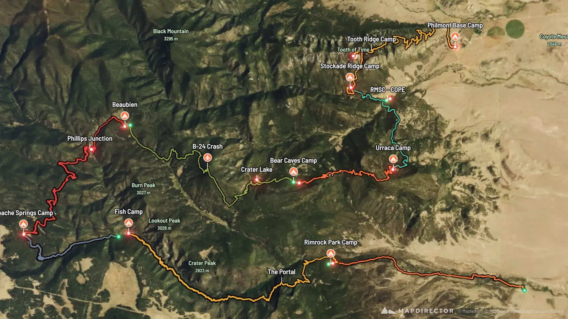
South Country - Itinerary 9-10
The timeline
By the numbers
- Distance
- 52.4 mi
- Ascent
- 9,174 ft
- Descent
- 9,119 ft
- Moving time
- 1d 01h 35m
Elevation profile
6,480 ft → 10,283 ft
Drag across the profile to follow the route on the map.
More stats
- Avg speed (moving)
- 2.0 mph
- Avg speed
- 1.1 mph
- Time
- 1d 22h 19m
- Avg cadence
- 52 rpm
Per leg
Rayado Trailhead to Rimrock Park
- Distance
- 5.52 mi
- Ascent
- 832 ft
- Descent
- 13 ft
- Moving
- 2h 22m
- Avg speed
- 2.3 mph
- Avg cadence
- 49 rpm
Rimrock Park to Abreu
- Distance
- 0.51 mi
- Ascent
- 32 ft
- Descent
- 201 ft
- Moving
- 16m 42s
- Avg speed
- 1.9 mph
- Avg cadence
- 38 rpm
Abreu to Fish Camp
- Distance
- 8.28 mi
- Ascent
- 1,760 ft
- Descent
- 385 ft
- Moving
- 4h 11m
- Avg speed
- 2.0 mph
- Avg cadence
- 53 rpm
Fish Camp to Apache Springs
- Distance
- 3.36 mi
- Ascent
- 800 ft
- Descent
- -
- Moving
- 1h 48m
- Avg speed
- 1.9 mph
- Avg cadence
- 50 rpm
Apache Springs to Phillips Junction
- Distance
- 5.94 mi
- Ascent
- 667 ft
- Descent
- 1,102 ft
- Moving
- 2h 52m
- Avg speed
- 2.1 mph
- Avg cadence
- 54 rpm
Phillips Junction to Beaubien
- Distance
- 1.89 mi
- Ascent
- 455 ft
- Descent
- 64 ft
- Moving
- 58m 35s
- Avg speed
- 1.9 mph
- Avg cadence
- 54 rpm
Beaubien to Crater Lake
- Distance
- 6.71 mi
- Ascent
- 1,277 ft
- Descent
- 2,245 ft
- Moving
- 3h 45m
- Avg speed
- 1.8 mph
- Avg cadence
- 54 rpm
Crater Lake to Bear Caves
- Distance
- 1.27 mi
- Ascent
- 98 ft
- Descent
- 118 ft
- Moving
- 35m 26s
- Avg speed
- 2.2 mph
- Avg cadence
- 49 rpm
Bear Caves to Urraca
- Distance
- 4.88 mi
- Ascent
- 681 ft
- Descent
- 1,112 ft
- Moving
- 2h 13m
- Avg speed
- 2.2 mph
- Avg cadence
- 53 rpm
Urraca to RMSC Cope
- Distance
- 3.37 mi
- Ascent
- 207 ft
- Descent
- 1,124 ft
- Moving
- 1h 28m
- Avg speed
- 2.3 mph
- Avg cadence
- 55 rpm
RMSC Cope to Stockade Ridge
- Distance
- 1.51 mi
- Ascent
- 508 ft
- Descent
- 60 ft
- Moving
- 39m 54s
- Avg speed
- 2.3 mph
- Avg cadence
- 44 rpm
Stockade Ridge to Tooth of Time
- Distance
- 2.89 mi
- Ascent
- 1,719 ft
- Descent
- 306 ft
- Moving
- 1h 35m
- Avg speed
- 1.8 mph
- Avg cadence
- 46 rpm
Tooth of Time to Base Camp
- Distance
- 6.27 mi
- Ascent
- 138 ft
- Descent
- 2,390 ft
- Moving
- 2h 45m
- Avg speed
- 2.3 mph
- Avg cadence
- 56 rpm