

Mapdirector
Loading
The Arctic Triple: LofotenUltraTrail 100Mby Andre Löffelmann

Ultramarathon·ultrarunning

The Arctic Triple: LofotenUltraTrail 100M
29 May 2026 – 30 May 20265/ 5

Mapped by

Andre Löffelmann

The story

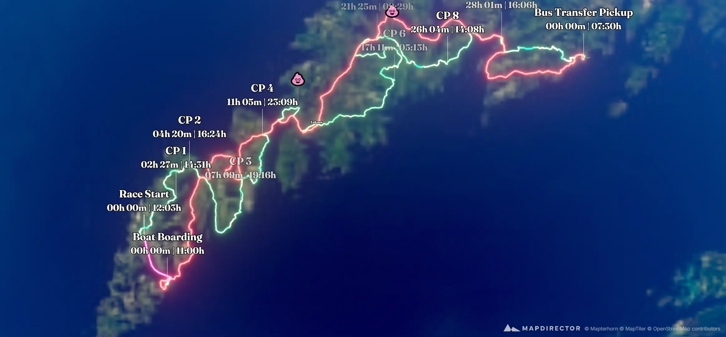
This has been by far the hardest race I have ever been through. Seems like Norwegians have another definition of "trailrunning" than us Central Europeans do. 12 hours of rain at the start 🌧️ at ~ 4⁰C 🥶 Completely soaked feet from the 4 km mark. Sodden, swollen soles of the feet from the 74 km mark. Mud. Deep mud. Mud nearly knee-deep in places. Trails? Nope. Pick your way through mire and swamp (at least most of the time), or "run" along the flooded path. Then, high-alpine scrambling. Traversing an exposed ridge after more than 25 hours and 150 km in the legs. And the downhill? Naturally, loads more mud 🫣 The whole thing was absolute madness 🤪 Came very close to quitting after the 58 km mark due to severe hypoglycemia 🤢🤮 Given that, grateful and happy to have finished the race within the cut-off time 🙏🏻 Crossing the finish line was a huge relief 😃 Out of 130 runners, only 51 made it to the finish line (within the time limit) - a DNF rate of ~61%. So I guess I can be quite satisfied with place 23 overall and 5th in age group 💪🏻 Norway, Lofoten: Incredibly beautiful, yet incredibly intense at the same time. Thanks @thearctictriple for this adventure! 😍

The timeline

By the numbers

Distance
296 km
Ascent
6,845 m
Descent
6,845 m
Moving time
1d 10h 59m

Elevation profile

-5 m → 609 m

Drag across the profile to follow the route on the map.

More stats
Avg speed (moving)
8.4 km/h
Avg speed
7.9 km/h
Time
1d 13h 14m
Avg heart rate
135 bpm
Max heart rate
175 bpm
Avg temperature
14.4 °C

Per leg

  • Hart, Härter, LofotenUltraTrail 100M 🤯

    Distance
    162 km
    Ascent
    6,039 m
    Descent
    6,039 m
    Moving
    1d 08h 03m
    Avg speed
    5.1 km/h
    Avg HR
    135 bpm
    Max HR
    175 bpm
    Avg temp
    14.4 °C
  • Boat Transfer

    Distance
    8.32 km
    Ascent
    -
    Descent
    -
    Moving
    26m 11s
    Avg speed
    19.1 km/h
    Avg HR
    72 bpm
    Max HR
    100 bpm
  • Bus Transfer

    Distance
    125 km
    Ascent
    806 m
    Descent
    806 m
    Moving
    2h 29m
    Avg speed
    50.0 km/h

Enjoyed this

Send it to someone

Your turn

Make a page like this from your own track

More from this explorer

See where else Andre Löffelmann has been

Powered byMapdirector
  1. Leg 1Bus Transfer125 km
    1. What's aheadFri, 29 May·07:30

    2. 295 km · 100%·10:30

      Reine

    3. 2 photos296 km · 100%·10:57 – 11:00

      Reine

  2. Leg 2Boat Transfer8.32 km
    1. What's aheadFri, 29 May·11:13

    2. 2 photos165 km · 56%·11:23 – 11:30

      Reinefjorden

  3. Leg 3Hart, Härter, LofotenUltraTrail 100M 🤯162 km
    1. What's aheadFri, 29 May·12:03

    2. 78 m · 0%·13:57

      Kirkefjorden

    3. 0.57 km · 0%·12:09

      12:09

    4. 2 photos1.38 km · 0%·12:22 – 12:25

      Reine

    5. 3.65 km · 1%·13:05

      13:05

    6. 4.84 km · 2%·13:25

      13:25

    7. 2 photos11.9 km · 4%·14:38 – 14:39

      Markvatnet

    8. 14.4 km · 5%·14:59

      Kvalvika Beach

    9. 15.6 km · 5%·15:21

      Slippery when wet...

    10. 3 photos15.9 km · 5%·17:28 – 17:38

      Kvalvika Beach

    11. 18.0 km · 6%·15:57

      15:57

    12. 2 photos22.0 km · 7%·18:44

      18:44

    13. 30.3 km · 10%·17:39

      Road to Nesland

    14. 34.5 km · 12%·18:10

      Nesland

    15. 38.8 km · 13%·22:42

      Nusfjord

    16. 2 photos39.1 km · 13%·21:10 – 21:15

      Nusfjord

    17. 39.4 km · 13%·20:39

      Nusfjord

    18. 2 photos42.1 km · 14%·19:39 – 19:46

      Storvatnet

    19. 50.0 km · 17%·21:26

      21:26

    20. 51.1 km · 17%

      Rockfall 😱

    21. 3 photos52.0 km · 18%·21:59

      21:59 – 22:04

    22. 🎒 DropBag #1 Rest for ~30minutes - fresh socks, fresh shoes, some food

    23. 59.8 km · 20%·23:56

      Tunnel to Offersøy

    24. 62.2 km · 21%·00:25

      00:25

    25. 63.8 km · 22%·00:49

      00:49

    26. 68.8 km · 23%·02:03

      02:03

    27. 80.0 km · 27%·03:37

      03:37

    28. 82.3 km · 28%·03:56

      03:56

    29. 2 photos85.8 km · 29%·04:24

      04:24 – 04:30

    30. 90.1 km · 30%·04:58

      Brustranda

    31. 95.4 km · 32%·06:29

      06:29

    32. 96.3 km · 33%·06:42

      06:42

    33. 🎒 DropBag #2 Rest for ~15minutes - fresh socks, fresh shoes, some food

    34. 2 photos117 km · 40%·10:47 – 10:54

      Vetten

    35. 2 photos125 km · 42%·12:45

      12:45 – 12:55

    36. 2 photos125 km · 42%·12:56

      Dalstuva

    37. 141 km · 48%·15:52

      15:52

    38. 149 km · 50%·17:42

      17:42

    39. 149 km · 50%·19:55

      19:55

    40. 2 photos149 km · 50%·18:08 – 18:10

      Jordtinden

    41. 2 photos151 km · 51%·18:46

      18:46 – 18:47

    42. 2 photos152 km · 52%·19:20

      19:20 – 19:25

    43. 156 km · 53%·20:30

      View to Tjeldbergtinden

    44. 3 photos157 km · 53%·23:15 – 23:16

      Tjeldbergtinden

    45. 158 km · 53%·23:27

      Tjeldbergtinden

    46. 158 km · 53%·23:37

      23:37

    47. 2 photos162 km · 55%·22:39

      22:39

    48. 162 km · 55%·23:48

      23:48

    49. 162 km · 55%·00:21

      00:21