

Mapdirector
Loading
Verbier Ultra 100by Stefan Bütler

Trail Run

Verbier Ultra 100
11 Sep 2026 – 13 Sep 20265/ 5

Mapped by

Stefan Bütler

The story

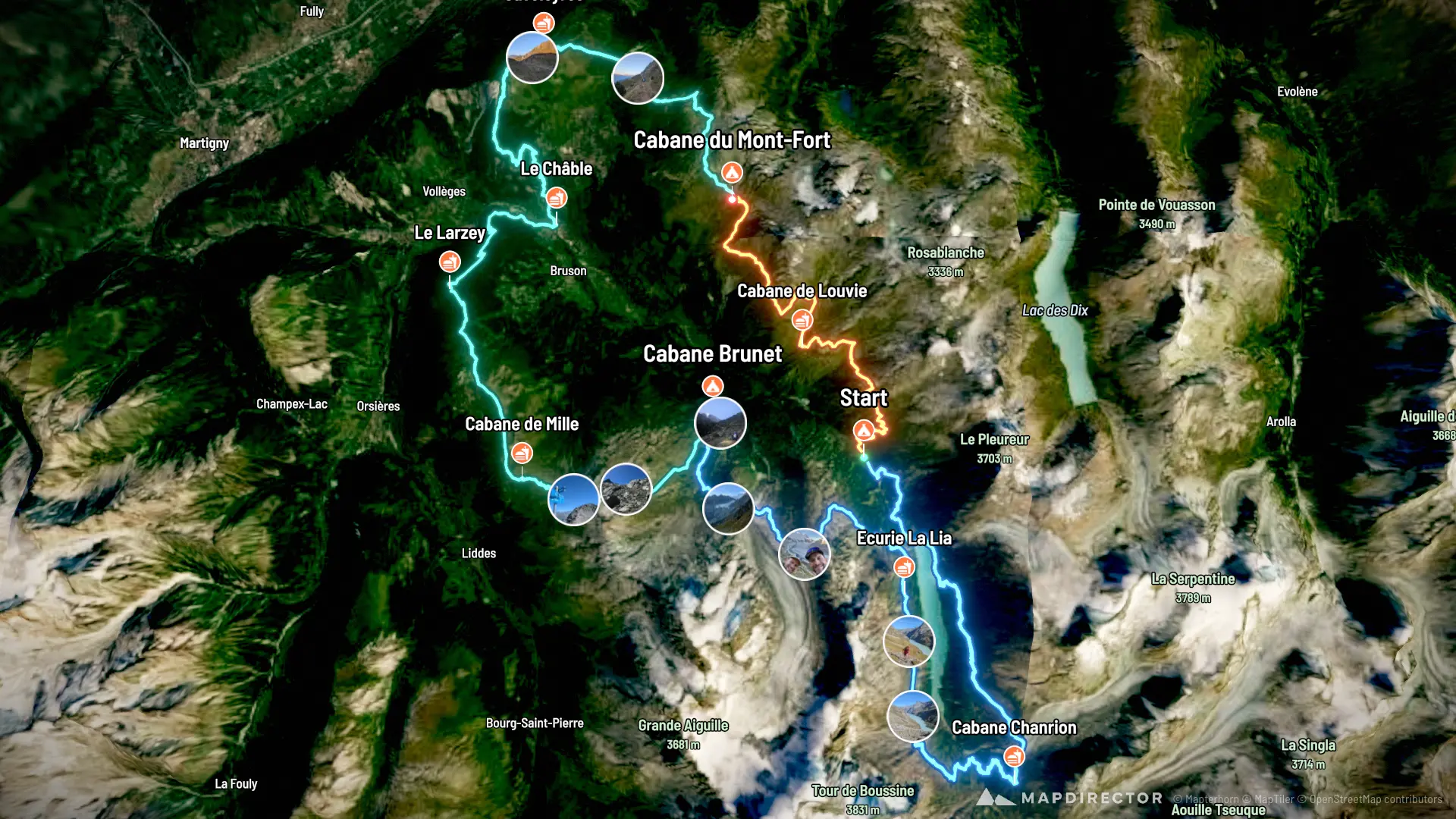
Verbier Ultra 100: Pure. Raw. Essential. The Verbier Ultra 100 is not a classic one-day ultra. It is a three-stage mountain adventure through the wild Val de Bagnes, covering around 100 kilometres and 8,000 metres of climbing. What makes the race special is its deliberately simple philosophy: Pure. Raw. Essential. Remote alpine trails, mountain huts and shared moments replace big-event infrastructure and spectacle. Runners move through some of the most impressive terrain around Verbier, with long climbs, technical descents and genuine high-mountain character. The result is a race that feels less like a conventional competition and more like a shared expedition through the Alps: demanding, intimate and deeply connected to the roots of trail running. For anyone looking for an ultra that combines serious mountain running with adventure and community, the Verbier Ultra 100 is one of the most distinctive events in Switzerland.

The timeline

By the numbers

Distance
98.3 km
Ascent
7,246 m
Descent
7,216 m
Moving time
19h 54m

Elevation profile

802 m → 3,065 m

Drag across the profile to follow the route on the map.

More stats
Avg speed (moving)
4.9 km/h
Avg speed
4.8 km/h
Time
20h 30m
Avg cadence
75 rpm
Avg power
182 W
Avg temperature
22.9 °C

Per leg

  • Stage 1 - Bonatchiesse to Cabane Mont-Fort

    Distance
    18.3 km
    Ascent
    1,860 m
    Descent
    990 m
    Moving
    3h 55m
    Avg speed
    4.7 km/h
    Avg power
    192 W
    Avg cadence
    71 rpm
    Avg temp
    22.1 °C
  • Stage 2 - Cabane Mont-Fort to Cabane Brunet

    Distance
    40.5 km
    Ascent
    2,895 m
    Descent
    3,234 m
    Moving
    7h 26m
    Avg speed
    5.4 km/h
    Avg power
    198 W
    Avg cadence
    76 rpm
    Avg temp
    21.9 °C
  • Stage 3 - Cabane Brunet to Bonatchiesse

    Distance
    39.5 km
    Ascent
    2,491 m
    Descent
    2,992 m
    Moving
    8h 31m
    Avg speed
    4.6 km/h
    Avg power
    164 W
    Avg cadence
    74 rpm
    Avg temp
    24.1 °C

Enjoyed this

Send it to someone

Your turn

Make a page like this from your own track

More from this explorer

See where else Stefan Bütler has been

Powered byMapdirector
  1. Leg 1Stage 1 - Bonatchiesse to Cabane Mont-Fort18.3 km
    1. 2 photosBefore the start·09:35

      09:35 – 09:40

    2. What's aheadFri, 11 Sep·10:00

      Distance: 19k Ascent: 2070m Descent: 1216m

    3. 2 photos1.89 km · 2%·10:25

      10:25 – 10:32

    4. 2.62 km · 3%·10:38

      10:38

    5. 4.50 km · 5%·11:05

      11:05

    6. 2 photos5.00 km · 5%·11:16

      11:16

    7. 3 photos7.79 km · 8%·11:54

      11:54 – 11:56

    8. 9.71 km · 10%·12:20

      12:20

    9. 2 photos12.4 km · 13%·13:00

      13:00 – 13:06

    10. After the finish·15:43

      15:43

    11. After the finish·17:37

      17:37

  2. Leg 2Stage 2 - Cabane Mont-Fort to Cabane Brunet40.5 km
    1. What's aheadSat, 12 Sep·06:30

      Distance: 41k Ascent: 3088m Descent: 3437m

    2. 4 photos20.8 km · 21%·07:00

      07:00 – 07:10

    3. 24.9 km · 25%·07:26

      07:26

    4. 27.1 km · 28%·07:46

      07:46

    5. 28.5 km · 29%·08:00

      08:00

    6. 38.4 km · 39%

    7. 3 photos47.2 km · 48%·11:31

      11:31 – 11:35

    8. 48.3 km · 49%·11:42

      11:42

    9. 52.3 km · 53%·12:40

      12:40

    10. 4 photos52.9 km · 54%·12:59

      12:59 – 13:04

    11. 3 photos53.4 km · 54%·13:13

      13:13 – 13:14

    12. 2 photos54.1 km · 55%·13:27

      13:27 – 13:34

    13. After the finish·15:18

      15:18

    14. After the finish·15:33

      15:33

  3. Leg 3Stage 3 - Cabane Brunet to Bonatchiesse39.5 km
    1. What's aheadSun, 13 Sep·06:34

      Distance: 42k Ascent: 2821m Descent: 3234m

    2. 59.4 km · 60%·06:39

      06:39

    3. 2 photos60.8 km · 62%·06:56

      06:56 – 06:58

    4. 2 photos62.8 km · 64%·07:33

      07:33 – 07:36

    5. 2 photos63.8 km · 65%·07:44

      07:44 – 07:52

    6. 4 photos64.6 km · 66%·07:54

      07:54 – 08:03

    7. 65.4 km · 66%·08:06

      08:06

    8. 2 photos66.6 km · 68%·08:22

      08:22 – 08:30

    9. 2 photos67.4 km · 69%·08:40

      08:40 – 08:47

    10. 2 photos71.8 km · 73%·09:36

      09:36 – 09:37

    11. 2 photos75.1 km · 76%·10:20

      10:20 – 10:25

    12. 77.3 km · 79%·10:48

      10:48

    13. 78.6 km · 80%·11:02

      11:02

    14. 2 photos82.6 km · 84%·12:03

      12:03 – 12:05

    15. 84.2 km · 86%·12:37

      12:37

    16. 85.3 km · 87%·13:01

      13:01

    17. 92.9 km · 94%·14:27

      14:27